Gene Bingham had an idea. Head of the chemistry department at Lafayette College in Easton Pennsylvania, he was a widely-published writer of the subject of research chemistry. Then, at 1926, at the age of 46, he pushed his life in a completely new direction.
North of Easton was a rocky ridge about 2,000 feet in height. Blue Mountain Eagle Climbing Club (abbreviated BMECC to avoid the tongue-twister official name) had begun building a hiking trail on the ridge, called, needless to say, “Blue Mountain.” The ridge ran from Delaware Water Gap, the border between Pennsylvania and New Jersey, all the way to the Potomac River in Maryland. The ridge line was periodically punched by gaps, forcing the hiker down into the gap and up again. But, though the trails that BMECC were building might be steep in the gaps, they were very moderate along the ridgeline. It made for almost ideal, though somewhat rocky, walking.
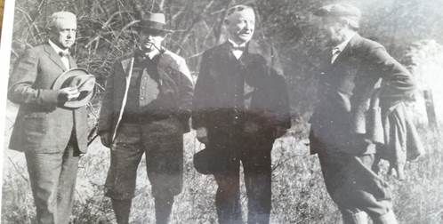
In 1926 Bingham established a hiking club at Lafayette College, called Blue Mountain Club (not to be confused with BMECC despite the similar name). Bingham, who had heard about Benton MacKaye’s new trail project, contacted BMECC and asked them to join his club in building the new trail from Delaware Water Gap to the Susquehanna River. BMECC leaders met with Bingham on October 30, 1926, after the annual hike to the spot of the eagle’s nest. Bingham’s club had already adopted the project to build a 35-mile section from Delaware Water Gap to Lehigh Gap, and suggested that it would be a great idea for BMECC to take on the rest of the project, 102 miles to the Susquehanna. Rentschler took the lead, and the club plunged enthusiastically into the project. The first work trip was recorded in Rentschler’s diary.
Sky Line Trail - 1st training, Sunday, Nov. 21, 1926. Members: Wm. R. Shanaman, Truman Temple, S.I. Goss, D.K. Hoch, Nick Phillipson, H.F. Rentschler, E.D. Greenawalt, Wm. Burkey, John O. Baer and nephew, Clarence Rahn. Left Reading at 9 o’clock; parked machine at John O. Baer home, Mountain, 10:45. Proceeded up the mountain. The trail was started by placing a marker close to the Berks and Lehigh Co. marker. Proceeded westward for ½ mile on the Drech road……to the high point known as Baer’s Ridge.[1]
In five years BMECC was ready to open the 20-mile section west of Port Clinton. This Berks section of the Appalachian Trail was formally dedicated on October 12, 1931. Benton MacKaye himself was present for the occasion.
[1] Rentschler diary, entry provided by Barbara Wieman Dec 30 2015. The site of the marker can be located with fair precision on the current ATC trail maps.
North of Easton was a rocky ridge about 2,000 feet in height. Blue Mountain Eagle Climbing Club (abbreviated BMECC to avoid the tongue-twister official name) had begun building a hiking trail on the ridge, called, needless to say, “Blue Mountain.” The ridge ran from Delaware Water Gap, the border between Pennsylvania and New Jersey, all the way to the Potomac River in Maryland. The ridge line was periodically punched by gaps, forcing the hiker down into the gap and up again. But, though the trails that BMECC were building might be steep in the gaps, they were very moderate along the ridgeline. It made for almost ideal, though somewhat rocky, walking.
In 1926 Bingham established a hiking club at Lafayette College, called Blue Mountain Club (not to be confused with BMECC despite the similar name). Bingham, who had heard about Benton MacKaye’s new trail project, contacted BMECC and asked them to join his club in building the new trail from Delaware Water Gap to the Susquehanna River. BMECC leaders met with Bingham on October 30, 1926, after the annual hike to the spot of the eagle’s nest. Bingham’s club had already adopted the project to build a 35-mile section from Delaware Water Gap to Lehigh Gap, and suggested that it would be a great idea for BMECC to take on the rest of the project, 102 miles to the Susquehanna. Rentschler took the lead, and the club plunged enthusiastically into the project. The first work trip was recorded in Rentschler’s diary.
Sky Line Trail - 1st training, Sunday, Nov. 21, 1926. Members: Wm. R. Shanaman, Truman Temple, S.I. Goss, D.K. Hoch, Nick Phillipson, H.F. Rentschler, E.D. Greenawalt, Wm. Burkey, John O. Baer and nephew, Clarence Rahn. Left Reading at 9 o’clock; parked machine at John O. Baer home, Mountain, 10:45. Proceeded up the mountain. The trail was started by placing a marker close to the Berks and Lehigh Co. marker. Proceeded westward for ½ mile on the Drech road……to the high point known as Baer’s Ridge.[1]
In five years BMECC was ready to open the 20-mile section west of Port Clinton. This Berks section of the Appalachian Trail was formally dedicated on October 12, 1931. Benton MacKaye himself was present for the occasion.
[1] Rentschler diary, entry provided by Barbara Wieman Dec 30 2015. The site of the marker can be located with fair precision on the current ATC trail maps.
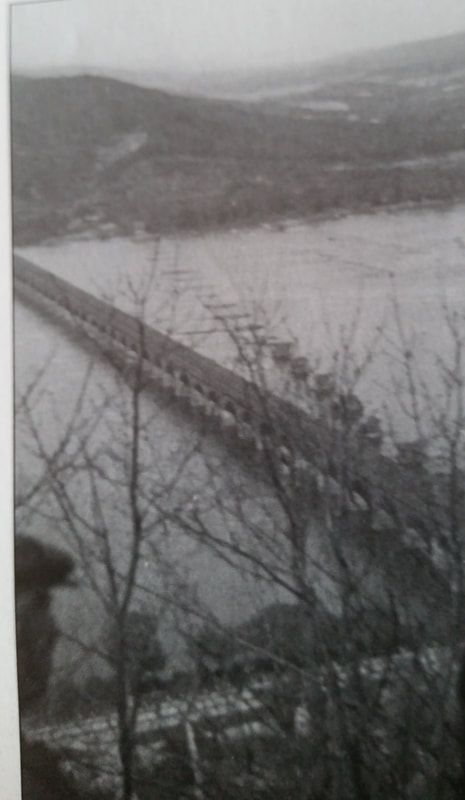
The trail in Pennsylvania was known originally as the Sky Line Trail, so named by the Blue Mountain Club. Its route from Delaware Water Gap to the Susquehanna faithfully followed Blue Mountain, moving along the relatively level ridgeline, through Lehigh Gap, Swatara Gap, and Manada Gap before reaching the river just north of Harrisburg. At this point it needed to connect with the Bishop Darlington Trail across the river, named for the Episcopal bishop of St. Stephens Cathedral in Harrisburg, and a prominent member of the Pennsylvania Alpine Club. But there was no direct connection - hikers either had to walk south to Harrisburg, cross the river on an auto bridge, and walk back north, or cross illegally on a railroad bridge that took it almost directly to the foot of Blue Mountain on the west bank of the river, where the Darlington Trail began. (There is no information about how many hikers dared to use the illegal and dangerous Rockville railroad bridge crossing (shown to the left). But it was there, and hikers tend to be adventurous.)
Rockville Bridge – The Chancy Route[1]
Pennsylvania thus had a long section of the AT built in the late 1920s and early 1930s. But the route west of the Susquehanna River confronted a problem that was to confound trail clubs for decades. South of Blue Mountain and the Darlington Trail was Cumberland Valley, farmland and private property. It would be difficult to bring a trail down through that area, so the Blue Mountain Club proposed to extend it along Blue Mountain all the way to Doubling Gap (present-day Colonel Denning State Park), then hooking down past Newville and south of Carlisle, a 30-mile road walk all the way to Pine Grove Furnace. From Pine Grove Furnace, Bingham’s map showed it proceeding along South Mountain, through the new Michaux State Forest and Mont Alto State Forest, and into Maryland at Blue Ridge Summit. Bingham’s proposed route took the trail all the way to the Potomac River three miles east of Harpers Ferry.
The ideas were admittedly primitive and not fully formed – perhaps Bingham himself would have admitted it. But, west of the Susquehanna, a new player emerged. Myron Avery, a 30 year-old lawyer, burst onto the scene, and the Appalachian Trail in Pennsylvania was never the same.
[1] Rockville Bridge was the longest stone-arch bridge in the U.S.