Hiking Around The Museum
Our Museum is all about hiking, so it's no surprise that there are a lot of great places to hike nearby. Here are a few ideas.
|
|
Appalachian Trail - Our Museum is located in one of the nicest sections of America’s most famous hiking trail. Heading northbound from Caledonia State Park, near U.S. Route 30, you travel over a moderately rocky trail to the immaculately maintained Quarry Gap shelter, considered by some to be the best shelter on the entire trail. Continue north through stands of mountain laurel and wild rhododendron, which bloom spectacularly in late Spring. Walk along stands of native oak, maple and pine past the Birch Run shelter. Soon, you’ll enter a beautiful meadow containing the Toms Run shelter.
Watch closely for the official halfway marker of the A.T., meaning you are approximately 1,095 miles from both Springer Mountain, GA and Mt. Katahdin, ME. This marker shows the approximate halfway point. The precise length of the trail varies from year to year due to trail relocations. After a couple of smaller road crossings, you’ll come to PA Route 233 and enter Pine Grove Furnace State Park. This is the home of the Ironmaster’s Hostel, the Park Store and the Museum. This portion is a rarity for the A.T.: a multi-use trail where bicyclists, equestrians and hikers can travel together. Soon, the A.T. turns right and proceeds as just a hiking path again uphill and out of the park. The trail follows a steady uphill path through more mountain laurel, Pennsylvania’s state flower, to the crest of South Mountain. Soon you come to the intersection with the Pole Steeple Trail. This is a worthwhile diversion discussed in another section. The A.T. continues on South Mountain in the woods of the Keystone State to the James Fry shelter, near beautiful Tagg Run. Eventually the trail descends, crossing Pine Grove Road along Hunter’s Run, alongside railroad tracks. Eventually it will take you to the picturesque trail town of Boiling Springs. Here are some parking lots near the trail where you can leave your vehicle and do a day hike. These are listed from south to north. Caledonia State Park, just off Route 30; Shippensburg Road; Furnace Stack parking lot at Pine Grove Furnace State Park; Hunter’s Run. The Museum's STORE, both online and in person, has a variety of maps and books with more information on the A.T. |
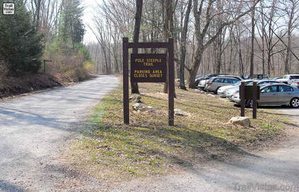
 Pole Steeple Trail parking lot Photo courtesy Trail Vistas
Pole Steeple Trail - This is a short, but difficult, trail within Pine Grove Furnace State Park that connects Laurel Lake with the Appalachian Trail. Parking is available in a lot off the Old Railroad Bed Road at the edge of Laurel Lake. The highlight of the strenuous uphill three quarter mile climb is the spectacular view from Pole Steeple, a large rock outcropping. In clear weather, you can see miles of the Park and the Michaux State Forest. Get a map of from the Park office.
Here are a few tips. There is an alternate trail partway up the mountain that avoids some of the steepest climbing. Here is a nice 6 mile loop hike that incorporates the A.T. and goes down the Pole Steeple Trail (much easier). Park at the Furnace Stack Parking Lot. Begin northbound on the A.T. (that’s away from the Ironmaster’s Hostel). After about two and a half miles, you’ll see a sign to the left for the blue blazed PST. Take that to Pole Steeple and enjoy the view. Continue on the PST down the mountain to the gravel road and parking lot. Follow the road to the left. After a bit more than a mile you’ll meet up with the A.T. Take it southbound this time back to the Furnace Stack Parking Lot.
Here are a few tips. There is an alternate trail partway up the mountain that avoids some of the steepest climbing. Here is a nice 6 mile loop hike that incorporates the A.T. and goes down the Pole Steeple Trail (much easier). Park at the Furnace Stack Parking Lot. Begin northbound on the A.T. (that’s away from the Ironmaster’s Hostel). After about two and a half miles, you’ll see a sign to the left for the blue blazed PST. Take that to Pole Steeple and enjoy the view. Continue on the PST down the mountain to the gravel road and parking lot. Follow the road to the left. After a bit more than a mile you’ll meet up with the A.T. Take it southbound this time back to the Furnace Stack Parking Lot.
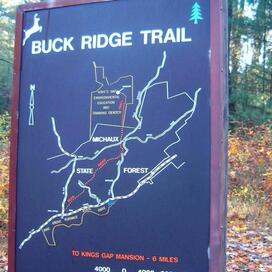
 Buck Ridge Trail map Photo courtesy CVVB
Buck Ridge Trail - This trail goes from Pine Grove Furnace State Park to another PA park gem, Kings Gap Environmental Education Center. It is approximately 7 miles long with blue blazes. Parking is available at PGFSP in a lot just north of the Park office along Route 233. Ample parking is available at Kings Gap as well. Kings Gap has several excellent trails of its own. Get a map of the Center there.
Other Trails In Pine Grove Furnace State Park - Our friends at the Park maintain an excellent website with tips on some more hiking opportunities. HERE's a link.

